Showing posts with label Hebridean islands. Show all posts

Friday, 15 August 2014

Journey's End

Lewis Castle has commanding views across the waterfront at Stornoway
Stornoway is the capital of the Outer Hebrides on the east coast of Lewis. The town's true beginnings are now lost in the mists of time, but it is known that it was founded by Vikings in the early C9 under the norse name Stjórnavágr. You feel as if you are well on your way to the top of the world, next stop north across the ocean being the Faroe Islands, Iceland, then Greenland.
Harbour reflections

A bronze statue of a herring seller on Stornoway waterfront  
The island women will vote "YES" to independence. I respect their choice but personally, I am hoping the majority vote is "NO" - it would feel like a bereavement in the UK family. Scotland is a part of my life, it is where we lived for several years, and where my eldest son and youngest granddaughter were both born. Now, however, that I have travelled to these far distant islands, I do appreciate just how remote from London they are. Indeed, they are also a very long way from Edinburgh as this journey back reveals.
But what's this notice in the window upstairs? - it seems not all islanders agree - "UK OK better together - A stronger Scotland, a United Kingdom"
Gaelic street names
Colourful fishing nets drying in the sun
The ferry has arrived, and
the end of our eight island adventure. So it's farewell to this beautiful archipelago of islands formed in the Precambrian period some three billion years ago
The journey takes almost three hours back to Ullapool on the Scottish mainland
On the return journey we saw dolphins, porpoises, guillemots, cormorants and a huge variety of seabirds flying overhead - some people also spotted cute little puffins
An overnight stay near the pretty packhorse bridge in the Cairngorms, a familiar spot if you follow this blog, and then a final journey down through Perthshire
 a walk along the riverbank, then over the River Tummel back into Pitlochry
More than 5000 Atlantic salmon swim up this river each year where they negotiate a salmon ladder installed by the Scottish Hydro Electric scheme to enable them to spawn higher up the river
Salmon Ladder
next stop Edinburgh, and a quick plane ride home 

Monday, 11 August 2014

Harris & Lewis

Berneray Island, reached via a recently built causeway from North Uist, has onward ferry travel to the Island of Harris and Lewis
via
Exquisite golden beaches and azure waters, are to be found at the southern end of Harris. Hardly a soul to be seen - it is pure magic
St. Clement's church on Harris was built by the MacLeod Clan Chiefs of Dunvegan and Harris as their burial place in 1520 but the church fell into ruins following the Protestant Reformation in 1560. It was rebuilt two hundred years later by Captain Alexander MacLeod, but sadly within three years it was badly damaged by fire. In 1873 the building was restored once more by the Countess of Dunmore. Inside is found one of the finest C16 tombs in Scotland - Alasdair Crotach MacLeod's Tomb.
The tomb is carved with images from the Bible but many of the carvings also demonstrate what was important to Alasdair in his life - a hunting scene with knight and two stags; a sailing galley; a castle (probably Dunvegan); the apostles; angels; Christ upon the cross; bishops; and a carved effigy of Alasdair in Armour lies below.
Crossing the border from Harris to Lewis a ring of stones with a great central monolith was erected during 2900 - 2600 BC known as Callanish or Calanais in Gaelic. However, within 5km of the main stone circle are at least 12 other standing stone sites.
A small burial chamber can be seen within the stone circle
The chamber was encased in a cairn and cremated bones and pottery placed within
We shall never know what inspired the stones' construction, but it is generally believed that Callanish functioned as an astronomical calendar associated with the moon. Although the true story is lost in time, its legacy lives on drawing people from around the world to see our ancestors hidden history
The circle of stones and the large central monolith
However fascinating the Standing Stones are, they are not the only prehistoric site worth visiting on Lewis. Dun Carloway is considered to be one of the best preserved Iron Age Brochs in the whole of Scotland. It lies high above a crofting township and is close to a large sea loch.
Brochs are amongst Scotland's most impressive prehistoric buildings - this stone roundhouse dates from about 2000 years ago. They are found mainly in northern and western Scotland, and were probably built to reflect the prestige and status of their inhabitants. They were primarily dwelling places with family areas, but would have also provided protection from the weather and against sporadic raiders.
The double-skinned drystone walls support each other and make possible a high building of relatively lightweight form. The roofing and interior structures of brochs are much debated
An impression of how Dun Carolway may have looked and been used
The Blackhouse, Arnol, Lewis
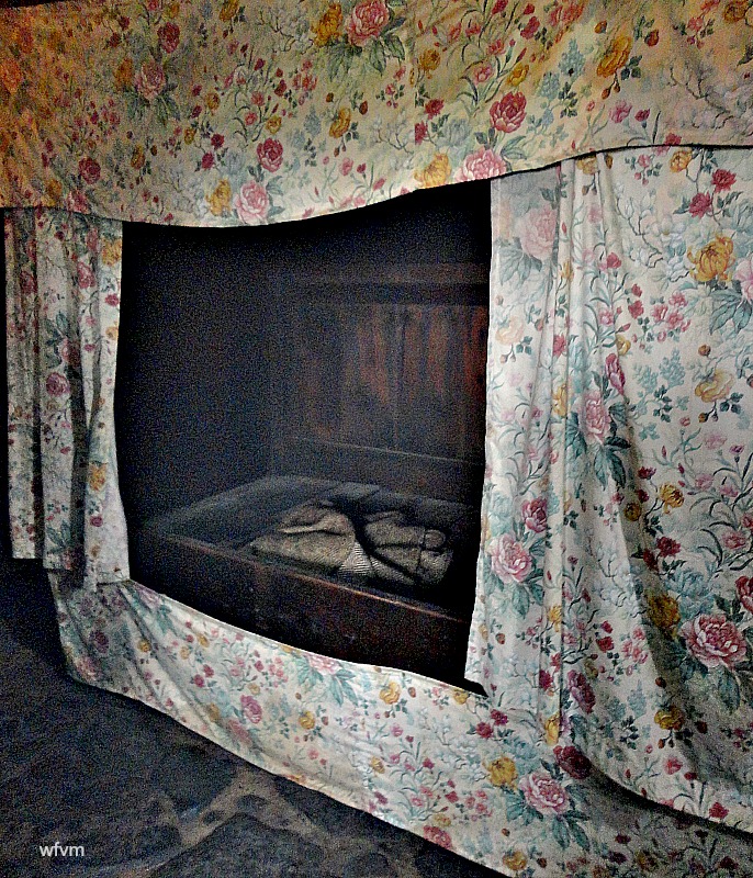
Two aspects of a blackhouse make it very different from a modern house - it was a residence for animals as well as people, and there were no chimneys. Animals living in the house had the advantage of making the house warmer and also meant that fewer buildings were needed. The smoke rising from the peat fire into the roof also had hidden benefits. It killed bugs, and the smoke-laden thatch, when removed, made excellent fertiliser for the fields. One wonders whatever it did to the lungs? This was the residence of a Hebridean crofting family and their animals until as recently as 1966.
mind your head as you enter!

The animal byre and stalls with a drain to the outside for the urine - it smells very, very, smokey in here!
Sleeping quarters
Now I know the reason why!
'The peat fire was the centre of family life and was never allowed to go out'
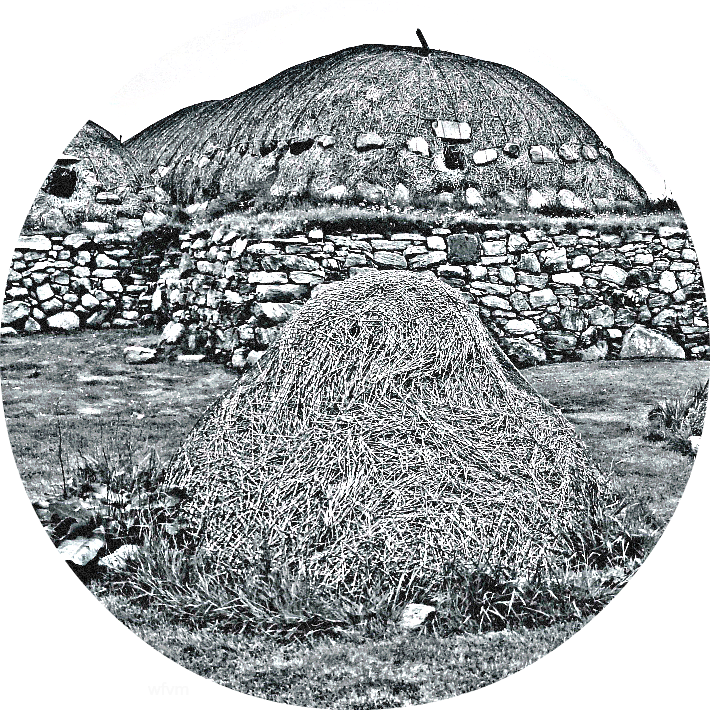
The thatch was made from oat straw, and replaced regularly. It was covered in a 'hairnet' of heather ropes, and weighted down with stones to prevent the wind and weather from blowing it away.
By the time we left the blackhouse everything about us smelt strongly of peat smoke, our hair, our clothes, and our bodies - poste haste to the hotel for us to take a refreshing shower

Tuesday, 29 July 2014

South Uist (4) North Uist (2) Benbecula (3) Eriskay (5) Berneray (6)

These islands are relatively flat in comparison with Skye and the northern Western Isles but wherever you are, distant mountains feature somewhere on the horizon. The islands stretch across the rim of the North Atlantic like a huge breakwater being home to a large variety of seabirds, seals, otters, dolphins, and whales.
This archipelago of islands features lots of fresh water lochs covered in small wild white water lilies, the roots of which supply a brown colouring to dye the wool used in Harris tweed cloth. 
Around the coast are sea water lochs which penetrate for several miles inland. These are lined with amber coloured sea kelp which the Crofters gather and mix with cattle dung to fertilise the land. 
Moors, bogs, beaches and interesting geological rocks combine to create some magical scenery. 
The area behind the dunes is called the Machair - a rare bio diverse coastal grassland with a total global area of just 19,000 hectares - 70% of which occurs in this Western Scottish area. Machair forms when sand with a very high shell content is blown landwards by prevailing westerly winds, creating a fertile low lying plain. Shell sand is calcareous - lime rich. It sweetens the peaty soil of the islands while facilitating drainage and warming in the spring. Although bleak through the dark winter months, the Machair is transformed during late spring and summer with the coming of the long hours of daylight into a spectacular floral display alive with insects and birds.
The crofters show a determined resilience by making full use of what nature supplies. For generations they have cut peat to warm their homes through the cold dark winter months. Timing and duration of the peat season is weather dependent but tends to begin in April with turfing - the removal of the first few mossy, heathery inches. Cutting the actual peat begins in May, and the skilled knowledge of how to cut and stack is handed down from generation to generation. Once drying is completed the stacks outside the home resemble upturned boats.
The islands are predominantly either Roman Catholic or Presbyterian. South Uist and Barra being the last remnant of native pre-reformation Scottish Catholicism, and the islands of Lewis and Harris are dominated by the Calvinist 'free church', they have been described as the last bastion of Sabbath observance in the UK.
Gaelic is the spoken language, although in a few areas English speakers form a majority.
A recently opened causeway now links Eriskay to South Uist - this beach on Eriskay is where Bonnie Prince Charlie came ashore on the 23rd July 1745, almost 269 years to the day that we too stood on this beach - it was his last attempt to reinstate the Stuart dynasty. 
the hills on the island of Barra
When I first began blogging I did a post which explains the reasons why we would have liked to visit Barra which I will show next time